Geologic Evolution of the Eastern Mediterranean
Towards the close of the Mesozoic, the seas retreated from the continents on a grand scale leaving the extended Tethys as the only inland sea. During most of the era the Tethys lay to the south of Europe. South of the Tethys, and continuous with it, epicontinental seas spread across North Africa, where thick sequences of nummulitic limestones accumulated, especially in Libya and Egypt.1
The northern margin of the Tethys extended from southeastern France round the northern side of the present Alps, then east to Austria, and continued in a sinuous course to the Middle East. The northern margin is much more heavily folded, especially in the Alpine region, than that of the southern margin of the Tethys. The only folded mountain ranges are in western Africa; in Morrocco, Algeria, and Tunisia.
The Triassic opening of the area now occupied by the Mediterranean was synchronous with the opening of the central North Atlantic and Gulf of Mexico along a complex set of spreading centers. The rifting and spreading formed continental margins, now poorly preserved in both North Africa and Europe. Oceanic sediments accumulated in the open ocean at the same time (approximately Jurassic) as continued platform sedimentation on both the North African and European shelves.
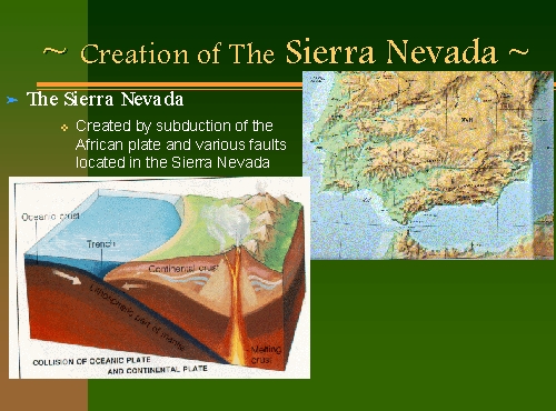
After rifting, the configuration of the central and eastern Mediterranean was dominated by the closure of Africa and Europe, partly shown by modern northdirected subduction along the Mediterranean-Himalayan belt.2 In the western Mediterranean, complex series of magnetic lineations indicates multiple directions and periods of seafloor spreading since approximately the Late Oligocene. Two major parts of the Mediterranean, the Aegean and Tyrrhenian Seas, were developed by back-arc spreading beginning in the Miocene.

A major event in the history of the Mediterranean region was the development of a suite Messinian (latest Miocene) evaporites exposed by uplift around the present basin margin and sampled by numerous deep-sea cores. "(Scientists) had expected to see finely compacted particles of silts and clays; instead they found pea-sized gypsum (calcium sulfate) gravel, which forms when seawater evaporates."3 The age of these deposits is about six million years; apparently at about that time the Strait of Gibraltar was temporarily closed due to the northward movement of the Arabian plate, preventing exchange of water with the Atlantic, and the Mediterranean simply evaporated away, leaving behind only the salt that had been dissolved in its waters.
Because the salt content of seawater is well known, it is a simple matter to calculate how much salt should have been deposited when the Mediterranean dried up. However, the observed thickness is much greater than could possibly have been formed during a single evaporation episode. It appears that the barrier to influx of Atlantic water was a fragile one that was periodically breached (presumably producing spectacular waterfalls into the Mediterranean basin in the process)4 , and that the thick salt deposits result from multiple cycles of filling and evaporation.
The present Mediterranean Sea largely occupies an area that was rifted apart in the early Mesozoic following the closure of Africa and Baltica. The northern rim of the Mediterranean and the western part of the southern margin are the sites of Mesozoic/Cenozoic compression orogeny broadly referred to as 'Alpine'. These mountain belts extend eastward through Asia Minor into the generally 'Himalayan' orogeny of the southern margin of Asia. There is still subduction going on in the Mediterranean region today, the result of the general northward movement of Africa and continued jostling between the Eurasian and African plates. In this process, part of the Mediterranean seafloor is being thrust under Europe.
1 Kummel, Bernhard, History of the Earth, 1970, W.H. Freeman and Co.: San Francisco, p.447
2 Murck, Barbara, Environmental Geology , 1996, John Wiley and Sons Inc.: New York, p.92
3 Garrison, Tom, Oceanography , 1996, Wadsworth Publishing: New York, p.114
4 Garrison, Tom, Oceanography , 1996, Wadsworth Publishing: New York, p.114