The Creataceous-Tertiary History of Bryce Canyon
by Jesse Mausner
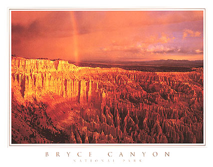
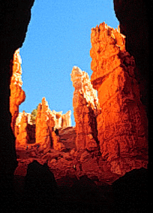
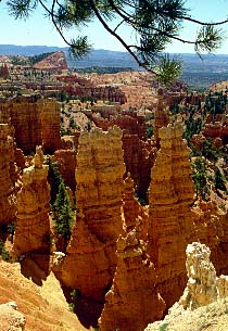
In mid to late Cretaceous times, from about 100 to 80 million years ago, there existed a large, extensive interior seaway in the Western interior foreland basin of North America. This foreland basin was formed just to the east of the Sevier Orogenic belt, which reached as far east as Wyoming and central Utah. This Sevier orogeny was most active during late Cretaceous times, and it caused subsidence of the foreland basin to its east, deepening the waters of the interior seaway. Approximately 80 million years ago, North America was migrating westward, and was sliding over the edge of the Pacific plate. This westward movement caused great compressional forces that spread eastward across western America. This soon became the Laramide Orogeny- another mountain building episode further east than the Sevier belt. The Laramide orogeny began to form the present day Rocky Mountains, and by about 60 million years ago, the region of southern Utah that is now Bryce Canyon was covered by an extensive system of marine lakes that were connected to the interior seaway further to the east. During this time, Bryce's most distinct formation- the Wasatch limestone- was deposited. This formation is striking for its many colors and different textures, it is not a uniformly limestone formation. The lake that it was formed in, called "Lake Flagstaff", covered thousands of square miles, but changed in size, shape, and sea level frequently. These changes are all reflected in the formation, as well as changes in sediment load and types of sediment deposited. The Wasatch formation grades from pure limestone to calcium-rich mudstones, to sandstone, conglomerate, and even limey shales. The alternating beds of the Wasatch formation are striking in color and texture, which helps give the formations at Bryce their scenic beauty. The red and pink colors of certain parts of the formation are from iron oxides, likely deposited at a time when the lake was a fairly inhospitible and oxygen-free environment. Beneath the Wasatch limestone is a large erosional unconformity representing millions of years of missing rock record, underneath which lies sandstone that is strikingly different from the Wasatch formation. As the Paleocene progressed, the interior seaway began to drain, and the marine waters receded from the foot of the Sevier orogenic belt to the east permanently. The region that is Bryce Canyon, however, was not uplifted until after the Oligocene (~35 mya), when there was extensive volcanic activity throughout southwestern Utah. No volcanic rocks are found within Bryce, but there are many on the park's periphery. Uplifting of the area began in mid-Miocene time, about 16 million years ago. The elevation of the Colorado Plateau began at this time, along with the Basin and Range Orogeny. The Colorado Plateau was uplifted more than 1.5 kilometers, and the faulting associated with this uplift broke the western part of the plateau into a few blocks called the High Plateaus. Bryce Canyon is located on one of these plateaus, called the Paunsaugunt Plateau. Much of the extensive faulting and jointing that is visible within Bryce today happened during this period of uplift. As this plateau was uplifted, the drainage systems began to carve their way into it, and the Paria river (a tributary of the Colorado) cut directly into the Paunsaugunt Plateau. The waters of the Paria easily cut through the soft Wasatch formation limestone, and are responsible for many of the spectacular erosional landforms at Bryce today. Weathering and erosion are the two dominant factors in the formation of the unusual shapes of rock at Bryce. When caprock (a piece of rock that is more resistant to weathering than its underlying rock) is exposed, weathering and erosion act on rocks beneath and surrounding the caprock, leaving the skyscraper-like formations at Bryce known as Hoodoos. The Wasatch formation has many joints (planes of weakness) that are vulnerable to weathering and erosion, so weathering and erosional processes along these joints causes the rocks to take certain shapes, like those we see today.
Links for further information:
Photos:
National Park Service Page: http://www.nps.gov/brca/
Information:
Sources