Chinese Hydrology Data Project
Overview
Where are the data from?
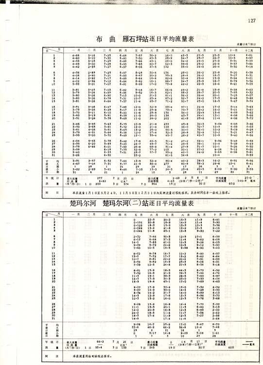
The data were collected by the Chinese Hydrology Bureau and published in annual yearbooks starting as early as 1919. There are two general types of stations avaiable - weather stations and hydrology stations. Some stations collect both types of data. Weather stations all collect precipitation data and some also collect evaporation data. The hydrology stations all collect stage data. Some also calibrate stage to discharge and report discharge data. A subset of these stations also collect total suspended sediment data. Most of these measurements are reported daily. Stations which collect discharge data measure discharge using cross-sections and flow-velocity calculations as many as 300 days a year (possibly daily at many stations). During the monsoon season discharge measurements are made as many as 5 times a day. Stations which collect suspended sediment concentrations collect along vertical profiles daily and calibrate their profile averaging at least 25 times a year (again, this may happen daily at some stations). Generally 12 hydrographers work at each station year-round.
Suspended sediment concentration and discharge data were collected daily using a Jakowski sampler and the 0.2 to 0.8 sampling method (Ministry of Water Conservancy and Electric Power, 1962, 1975).
What are the potential errors in the data?
Galy and France-Lanord (2001) show that the quantity of sediment carried suspended in a river is highly non-uniform over the cross-section of the river. There are no errors reported with the original Chinese data, thus I report none, but that is not to say that there are none. Singh and France-Lanord (2002) show that point sampling is generally not representative of the total suspended load. Additionally, all we know about the collection method is that they are collected with "standard" procedures, so we cannot evaluate what magnitude of sampling errors are associated with them.
An additional source of error in the data is the location of stations. The station locations are, for most stations, reported to the nearest minute. The upstream area, town, and river for each station are also reported. If the data are being used to calculate basin wide erosion rates, the station will have to be moved to a nearby river with the correct upstream area. This is less of a problem for stations on major rivers since we know the location of these rivers (such as the Red, Mekong (Lancang), Salween (Nu), etc.) but is a problem for tributary rivers since often the information is non-unique (such as "Left branch"). I am not publishing where I put the stations after extensive experimentation and calculating upstream areas because I think it is best that everyone use their own best judgment about where the stations belong. Additionally, some stations do not have locations recorded in all years or periodically moved. These data are all reported in the front_of_books table.
Wang et al. (2007) estimate errors in discharge measurements of 1-2% and 16% in daily suspended sediment concentrations.
What data are available?
For details on exactly what stations have which data, the "front_of_books" table has information for each book and can be queried by year, station number, and so on. The data structure page has the information you need to do these queries.
I have not digitized all of the data for the entire country and probably never will be able to do that. To start with, only data collected prior to 1987 are somewhat in the public record. Secondly, I only have the books for the Yunnan-Tibet International Rivers (district 9), the Yalong and Jinsha sections of the Yangtze River district (district 6-1), and the Fen He sections of the Yellow River district (district 4-4). As of Winter, 2009, we have typed up all of the data for Tibet and the discharge and sediment yield data for the Yunnan International Rivers.
Please contact me if you are interested in data which has not yet been digitized or if you have more data to add to the database.
|
|
 A sample page of a book
 |